Create a folder somedir
From you satnav, get a GPX file: ams.gpx
Put some nice photos in the folder. i150830a.jpg, i150830a.jpg, i150830b.jpg
Use a plain text editor to create the rourcefile in the same folder.
[Header]
    Title: Gouda biketrip
    Template: routetemplate.tpl
    Markers: leaflet/markers.js
    gpxifn: gouda.gpx
    Thumb: i150830a.jpg
    [A]
    M: 52.034, 4.765
    F: i150830a.jpg
    C: comment1
    [B]
    M: 52.04166, 4.72220
    F: i150830b.jpg
    C: comment2
Notes:
[C] lines that start like this are ignored.
M = map location Lon/Lat.
F = Foto filename.
C = Comment or Caption for the photo.
webroute.py ams.rc /somedir/amsterdam
This will process the gouda.rc + the photos + gouda.gpx and create html in directory: somedir/gouda
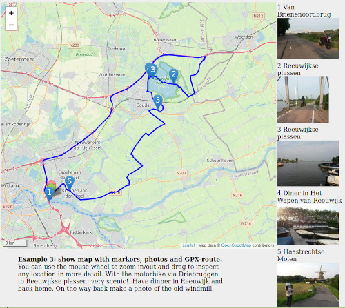
It should look like this:
Note this is just a sceen image. When you open the index.html with a web browser like firefox than it will make the view dynamic: you can zoom/out move north,south,east,west. In some demo's click on the marker to see the photo.
Henk Speksnijder 20210527